|
Jharkhand
OVERVIEW
The hype, the glitter, the urban settings and even five
star hospitality are conspicuous by its absence in this
state. Not with standing all these, the ripple of the
falls as they cascade down steep mountain slopes seem
as mighty as Lord Shiva's Tandav. History stands still
amidst the serenity of hundreds of years old rich teak
forests of Saranda that have witnessed the rise and
fall of the British Empire.
Jharkhand, formerly a part of United Bihar became the
28th State of India on 15th November 2000. The capital
of Jharkhand is Ranchi.
Jharkhand is a mineral rich state, having most of big
industries of United Bihar. There are two major steel
plants- Tata Steel at Jamshedpur and SAIL at Bokaro,
several coal mines fields, Heavy Engineering plant at
Ranchi, a big fertilizer plant at Sindri and several
industrial establishment based on minerals in this state.
Jharkhand state is full of evergreen forests, wild life
sanctuaries, lakes, waterfalls, health and holiday resorts
and a wide range of scenic beauty for tourists. The
State's Chota Nagpur plateau presents a rolling hills
area, dense forests, several waterfalls and many springs
with mineral waters.
Jharkhand state is not only a state of abundant evergreen
forests or wildlife or waterfalls but also a state of
important pilgrimage destinations. The famous places
of pilgrimage are Rajrappa, Parasnath, Sun Temple, Baidyanathdham
(Deoghar), Jagannathpur Temple and Hill, Anjangram and
many more.
Jharkhand also is developing Ecotourism and Organic
Farming destinations, where quite a few villages are
turning as eco tourism destinations, and farms being
converted to Organic Farming.
Fast Facts
Area: 79,714 Sq. Km
Capital: Ranchi
Climate: Pleasant and equable throughout the year.
Clothing : Summer - Light Cottons
Winter - Heavy woollens.
Languages spoken
Santhali, Mundari, Kurukh, Khortha, Nagpuria, Sadri,
Khariya, Panchparagnia, Ho, Malto, Karmali, Bhojpuri,
Hindi, Urdu, Bengali
Best Time to visit
February to April
For further information log on to http://www.jharkhand.nic.in/tourism/tour.htm
Baidyanath Dham (Deoghar)
Overview
Baidyanath Dham situated in the Santhal Parganas of
Jharkhand is a very important pilgrim Center. It's famous
for the Hindus for the temple of Shiva-Baidyanath and
the place is a popular holiday Center.
General Information
Temperature (deg C):
Summer - Max 36.9, Min 23;
Winter - Max 27.7, Min 7.4.
Best Season: October to February.
Access
One can reach here by Train or by Bus. There is a station
called Jaisidih, about 7 km. far from this place on
Hawrah-Patna rail line of Eastern Railway. Daily bus
service is also available from Ranchi and other major
cities.
Places Of Interest and Excursions
Baidyanath Temple: Nandan Pahar; Naulakha Mandir; Satsang
Ashram; Tapovan.
Basakinath Temple: Famous for Shiva Temple.
Harila Joria: Famous for Shiva Temple.
Trikut: Sources of the River Mayurakshi.
Miscellaneous
Shopping Centres: State Handloom Emporium
Santhal Parganas Gramodyog Samitee
Santhal Parganas Khadi Gramodyog Bhavan
Yoga Institution: Balanand Ashram Yogashala, Karnibagh.
Other tours
(1) Ushri Falls (Giridih),
(2) Rajgir-Nalanda- Pawapuri
(3) Messanjore
Bokaro
Overview
The Bokaro District of Jharkhand State was created in
the year 1991 by carving out one subdivision consisting
of two blocks from Dhanbad District and six blocks from
Giridih District. The District Headquarter B S City
is having latitude of 23.29 and longitude of 86.09.
District Bokaro has a Geographical area of 2861 sq Km
and 357663.36 Hectares of Land. The Average altitude
of the Land is 210 mtrs from mean sea level. Situated
in the Chhotanagpur Plateau, the vast rolling topography
of the city is typical, strewn by graded valleys and
winding streams. In this setting, within a short period
of two decades, a new city with a strong multi-dimensional
economic base has blossomed into a regional urban centre
of around 8.0 lakh people drawn from different parts
of the country, giving the city the character of Mini
India. This city is also called Bokaro Steel City.
Access
Air: There is no direct air connection but SAIL is having
a private air belt at Bokaro.
Rail: Bokaro is near Dhanbad, which is on the main Delhi-Howrah
railway line.
Road: Well connected with all the major cities by good
motor able roads. Place of interest
Accommodation

Places of Interest
Bokaro Steel City: As the fourth integrated steel plant
in the Public Sector, Bokaro Steel City was conceived
in 1959. Bokaro Steel Plant actually started taking
shape in 1965 with the collaboration of the then United
Sovereign Of Soviet Republic. Major coalfields are located
nearby. Bokaro City was built to provide housing and
other community facilities for the plant's employees.
Garga Dam And Parasnath Hills: Bokaro City is located
in picturesque surroundings on the southern bank of
river Damodar with Garga, one of its tributaries meandering
along the southern and eastern outskirts of the city.
On the north, the city is flanked by the high ranges
of the Parasnath Hills and on the south just beyond
the river Garga, it is enveloped by the Satanpur hillocks.
Bokaro Ispat Pustakalaya: Located near Bokaro Niwas,
it has a collection of over 40,000 books that meets
the reading requirements of the people in the township.
City Park: Bokaro has a well-maintained City Park with
an artificial lake. Recently three artificial islands
have also been created.
Jawaharlal Nehru Biological Park: A Biological Park
named after Jawaharlal Nehru with a variety of animals
and birds and a modern aquarium is another attraction
located in sector 5.
Babudih: A village in Chas Block famous for 75 feet
high tower.
Chandrapura: A town famous for Chandrapura Thermal Power
Station.
TenuGhat: Headquarter of Bermo sub division famous for
Tenughat Dam and Tenughat Thermal Power Station
Dhanbad
Overview
Dhanbad is one of the most important industrial centers
in India. In and around Dhanbad is the richest mineral
wealth of India. It is situated about 168 km from Ranchi.
Dhanbad district was constituted in 1956 by carving
out the old Dhanbad subdivision, Chas and Chandankiyari
police stations of the Sadar subdivision of the erstwhile
Manbhum district. Dhanbad is Police district since 1928.
Dhanbad is the chief town and the headquarters of the
district.
General Information
Location - The Dhanbad district is situated in the state
of Jharkhand and lies between 23o37'3" N and 24o4'
N latitude and between 86o6'30" E and 86o50' E
longitude.
Climate - The climate of the district is characterised
by general dryness. It is very pleasant during the cold
weather from November to February. Thereafter the climate
becomes warm. It remains hot until the monsoon breaks
towards the middle of June. With the setting in of rains
the temperature falls and humidity rises, July to October
are the rainy months. July and August are the wettest
months. The average rainfall during July is 287 mm and
that in August 445 mm. The average annual rainfall in
the district is approximately 1300mm.
Temperature (deg C) : Summer Max- 44, Min- 22; Winter
Max.-22, Min- 8.
Best Season: October to March.
Clothing's: Summer - Cotton/Tropical; winter - Light
Woolen.
Languages Spoken: Hindi, Bengali and English.
Access
Air : Dhanbad airport is not functional at the moment.
Nearest airport is Ranchi, which is connected to Delhi
and Kolkata.
Rail : Dhanbad has an important railway station on Eastern
Railway and is very well connected with Patna, Kolkata
and other important cities in India.
Road : Dhanbad is very well connected by road with important
towns in Jharkhand.
Places to visit
Chark Khurd - The village, situated about 10 Kms from
Tundi on the Dhanbad- Govindpur -Giridih Road, is noted
for its hot spring .
Charak Pathar - The village is situated in GOVINDPUR
development block. It is a very large ancient boulder
of white stone. It derives its name from this stone.
Chati Gobindpur - The village is located in GOVINDPUR
development block, contains two ancient pillars which
are locally associated with Emperor Asoka and the Afghan
Chief Sher Shah.
Gopalpur - The village lies in Nirsa-cum-Chirkunda development
block. It contains an ancient pillar said to date back
to the time of Emperor Asoka. There is also a large
stone image said to be of Asoka himself.
Jhangi Mountain - This is the longest mountain of the
Jharkhand. This is situated in the way of Dhanbad to
Govindpur.
Jhinjhipahari - The village is situated in Baghmara
development block. It is said that an ancient temple
of Lord Shiva was found when the mines here were being
worked.
Maithan Dam - This Dam is situated at about 52 km. from
Dhanbad district. This is the biggest Dam of Damodar
Ghati Pariyojna. This Dam has been built to control
flood in the Barakar River. The reservoir of Maithan
Dam is spread in 65 sq. km. In the mid of this reservoir,
there is an island. A rest house has been built in this
island. Boating & fishing facilities are also available
in this reservoir. There is a Deer park and Birds garden
near this Dam these are also of a tourists importance.
Meva - The village is situated in Nirsa-cum-Chirkunda
Block. It contains ancient pillars said to date back
to the time of Emperor Ashoka. There is also a large
stone image said to be of Ashoka himself.
Panchet - This is also a census town situated 9 Kms.
South of Chirkunda and about 54 Kms. South east of Dhanbad.
The Panchet Dam, around which the Township has developed,
is located here.
Panchet Dam - This is situated about 16 km from Maithan.
This is the longest dam in Damodar Ghati Pariyojna.
Panrra - The village, which also lies in Nirsa-cum-Chirkunda
Block, it said to have derived its name from the Pandavas.
According to local legend the Pandavas spent some period
of their exile in hiding at this place. The village
contains an ancient temple of Lord Shiva known as Pandeweshar
Mahadev. The temple is believed to have been constructed
by Hindu King at a much later day.
Tetulia - Just near the Damodar River in the Dhanbad
district, there is a spring of hot water.
Topchanchi - The village is the headquarters of the
development block being the same name. It is situated
on the Grand Trunk Road. The Parasnath Hill is located
nearby. The Topchanchi Water Reservoir spreads over
an area of 214 Ac. It is a noted picnic spot.
Topchanchi Reservoir - This is situated about 37 km
from Dhanbad district. This is the artificial reservoir.
Mountains and forests surround this reservoir. This
spot is a well place to celebrate picnic and holiday.
Boating facility is also available here. There is also
a wild animal park near it.
GARHWA
Overview
The district is surrounded by river Sone in the north
Palamu district and area of Chattisgarh in the south;
Palamu district in the east and Sarguja district of
Chhatisgarh and Sonebhadra district of U.P. in the west.
Garhwa is famous for Saruat Mountain. This district
is situated at the border of Bihar.
Access
Garhwa is well connected with roads and railway. Daily
bus services are available from Ranchi and major districts
of Jharkhand, Bihar and Chhatisgarh.
Places of Interest
Saruat Mountain
This mountain is situated at the meeting point of Jharkhand,
MP and UP. This mountain has spread in 25 km. The highest
point of this mountain is Gugupat (3819 ft). The temperature
on this mountain remain 3.5 0 c in summer season. This
is the best tourists spot in Garhwa to enjoy holiday
in a very peace environment. The greenery of the mountain
attract the people.
Parasdih Water Fall
This waterfall is situated in Parasdih village of Bhawanathpur
block. Water fall here from the height of 370 ft. The
scene of this fall is very attractive and pleasant.
Sukhdari Water Fall
This waterfall is situated at the border of Jharkhand,
Chhatrisgarh and UP just near the Kanhar river. Water
falls here from the height of 100 ft. Its beauty is
very very attractive.
Gunga Jhanjh Water Fall
This waterfall is situated in Hesatu village of Garhwar
district. Water falls here from the height of 100 ft.
This is the stating point of Haraiya river. This waterfall
is good to enjoy picnic.
Hazaribagh National Park
Overview
Nestling in low hilly terrain, at an average altitude
of 1800 ft. (615 meters) this 183.89 sq. kms the Hazaribagh
National Park has an abundance of wild animals like
the wild Boar, Sambar, Nilgai, Chital, Sloth Bear, tiger
and Panthar. The 1970 census has established the presence
of 14 tigers, 25 Panthers and 400 Sambars. Hazaribag
is situated about 93 km from Ranchi above 2019 ft from
sea level.
Access
Hazaribag is well connected with roads and railway lines.
Daily buses and trains are available from Ranchi and
other major cities of Jharkhand and Bihar.
Air : The nearest airport Ranchi (91 kms) is connected
with Kolkata, Patna, Lucknow and Delhi by regular Indian
Airlines service.
Rail: Nearest railway station is Koderma which is 59
kms away or alternately one can apporach the National
Park from Hazaribagh Road railway station (67 kms) on
the Howarh-Delhi line.
Road: Hazaribagh town is connected by road to Ranchi
91 kms, Dhanbad 128 kms, Gaya 130 kms, Patna 235 kms,
Daltonganj 198 kms, Kolkata (via Asansol-Govindapur-Barhi)
434 kms.
Bus : The Hazaribagh National Park is 19 kms from the
Hazaribag town. Regular bus services connect the town
with Koderma, Hazaribagh Road rly station, Patna, Gaya,
Ranchi, Dhanbad, Dalotongunj and other nearby places.
Internal Transport: Unmetered Taxis, Auto Ricksaws,
Cycle Ricksaws and Taxis are available for the park
from the Hazaribagh town.
GENERAL INFORMATION
Temperature (deg C):
Summer Max. 41.1 Min 19.4
Winter Max. 25.5 Min 7
Best Season: October to March.
TOUR IN THE PARK
Trip to the park starts at 1700 hours from the Divisional
Forest Office, West Division, Hazaribagh and it ends
at 2200 hours. Rs.50 per head.
Reservation: Divisional Forest Officer, West Division,
Hazaribagh.
Entry fees for vehicles inside the park: Bus (full)-
Rs.75; Mini Bus- Rs.50; Station Wagon/Car/Jeep/Private
Car- Rs.20; Motor Cycle- Rs.10 and Taxi- Rs.25.
Guide Service: No charges for guides provided with the
tours.
Camera Fee: Nil.
Spot Light Fee: Rs.20 per trip.
Restriction: Firearms are not allowed inside the National
Park.
EXCURSIONS
Canari Hill (5 kms): Cycle Rickshaws available from
the Hazaribagh town.
Rajrappa Falls (89 kms): State Transport Bus operates
daily an early morning service to this place from the
town.
Suraj Kund (72 kms): Hot spring. Buses are available
from the town.
JAMSHEDPUR
Overview
East Singhbhum District with its Headquarters at Jamshedpur
is situated at the extreme corner of the southeast of
Jharkhand. Jamshedpur is situated about 209 km far from
Ranchi in the south-east side. This is the steel city
of India. This city is situated at the meeting point
of Kharkoi and Swarnrekha Rivers. This city has been
established by Jamshedji Nasserwanji Tata in 1907 at
Sakhchi village.
General Information
Legend has it that in the past, large number of lions
were found in this area. Subsequently this geographical
area has been named as Singhbhum "Land of Lions".
Before independence the same area of this district was
a part of old Manbhum District and Old Dhalbhum Estate.
After independence it has been merged with the Greater
Singhbhum.
Access
Jamshedpur is well connected with Buses, Trains and
Airplane. Regular bus services are available from Ranchi
and other major cities of Jharkhand and Bihar. Several
express trains are available.
Nearest air service available from
Netaji Subhash Chandra Bose International Airport at
Kolkata - 226 km
Birsa Munda Airport at Ranchi - 106 km (for Patna, Delhi
and Mumbai)
Nearest Railway Station Tatanagar
Roadways - Jamshedpur is on National Highway No. 33.
Places to visit
Jubilee Park - Jubilee Park is situated at the heart
of the city. Tata Steel presented this park to the citizens
of Jamshedpur in its Golden Jubilee Year in 1958. The
lush green park is spread over an area of 237.75 acres
and is dotted with flowerbeds and illuminated fountains.
The park has been designed around a central axis running
from the founder's statue at its highest point. The
focal point of the park is the breathtakingly beautiful
Moghul Garden, which is inspired by the Brindaban Gardens
at Mysore. Any ardent lover of roses will love the captivating
Rose Garden, which houses over 1000 varieties of roses.
The park's horticulture garden is renowned for its hybrids
it has developed. The three coloured fountains at the
center of the park attract evening visitors by hundreds
and are illuminated every Tuesday and Saturday.Every
year on 3rd March the entire park is lit up with lights
and the resplendent fountains are specially illuminated
to commemorate the birth anniversary of Mr. Jamshedji
Nusserwanji Tata, founder of the Tata Empire. Tourists
from all over the world come to have a glimpse of the
park on this notable day.
Tata Steel Zoological Park: A variety of flora and fauna
exists in condition close to their natural habitat at
the zoological park. Situated besides the Jubilee Park,
it is a treat for all the nature lovers. Any one can
closely observe the flourishing nature here without
a microscope. Migratory Birds visiting every year during
winters is equally enchanting for all the bird lovers.
The park also has a beautiful lake, a boathouse and
"Machaan Restaurant".
Jayanti Sarowar : earlier known as Jubilee Lake is spread
over an area of 40 acres. The sarovar was specially
dredged and deepened for boating. There is an island
at the center of the lake, which adds immense beauty
to the lake.
Sir Dorabji Tata Park : Manicured Lawns and flowerbeds
and brilliantly lit fountains provide a delightful touch
of color to the park, named in the memory of eldest
son of J N Tata. The park is situated in the center
of the city close to the Keenan Stadium.
River's Meet : Popularly known as "Domohani"
is the scenic confluence of the Kharkai and Subarnarekha
rivers. Watching the glorious brazen sunset by the "sangam"
of two rivers amidst the tall Eucalyptus trees is extremely
enchanting. It is located at the northwest tip of the
city. It was because of the unfailing water supply of
these two rivers that Sakchi was chosen over Sini as
the site for Tata Steel Plant.
Hudco Lake : Nestled in the picturesque and hilly terrain
of Telco Colony, the lake is a delightful retreat for
those desirous of being in-nature within the city precincts.
A wild hill besides the lake has been specially renovated
into a scenic park known as Sumant Mulgaonkar Park.
One can feast his eyes with the panoramic view of Steel
Industry and equally appealing sight of Tata Engineering,
Lafarge Cement and Tata Powers from the hilltop. A look
from the top says the complete story on why Jamshedpur
is called the "Green City" first and then
the "Steel City". A must see for everyone
visiting Jamshedpur.
Dalma Wildlife Sanctuary : Dalma Mountain Range is at
an altitude of 3000 feet. Lurking in the thick cover
of its jungle (193 sq. km.) are elephants, barking deer,
sloth beer, porcupines, leopard, tigers etc. The steep
slopes of Dalma are a trekker's delight. Small hideouts
have been made at several places in the sanctuary where
one can see wilds animals in their natural habitat.
A look from the mountaintop at the city is so visually
appealing at the night that it looks as if millions
stars twinkling. Dalma provides natural air condition
to the fuming steel city and is an important source
of fresh oxygen to the citizens. Late Sanjay Gandhi
inaugurated the sanctuary in 1975. On the mountaintop
are the guesthouse of Tata Steel and Forest Department.
There is also a temple of Hindu diety Shiva on the mountaintop
and the devotees throng to it during "Shivaratri".
Dimna Lake : Located at a distance of 13 km from the
city limits, at the foot of Dalma Hills, its salubrious
surrounding is ideal for outing. People from all across
the region come here during December-January for picnic.
Tata Steel has constructed this lake as a water reservoir
for its plant and the city.
PALAMU
Overview
The District of Palamu lies between 23 degree 50'and
24 degree 8' north latitude and between 83 degree 55'
and 84 degree 30' east longitude. It encompasses an
area of 5043.8 square Kms. The administrative head quarter
is Daltonganj, situated on Koel River in 24 degree 3'
north, and 84 degree 4' east. The distance between Daltonganj
and Ranchi is 165 Km.
The early history of PALAMU is not authentic but there
are legends about it. It is, however certain that kharwars,
oraons and cheros, the three aboriginal races practically
ruled over the tract. The kharwars claim to be Suryavanshi
Kshatriyas (Surya Vansha: The Dynasty/lineage of Sun
God; Kshatriya: The Warrior sect). They trace their
decent from Ajanagara or Ayodhya. Karusa was the sixth
son of Manu Vaivasata and he was assigned the eastern
territory. The descendants of Karusa were called Karusas
who subsequently came to be known as Karwars or kharwars.
According to tradition they were the rulers of Rohtasgarh.
The kharawars point to the days of the Pratapadhaval,
one of the line of chiefs who ruled there in the twelfth
century A.D., during the time of their greatest prosperity.
Climate
The climate of this District is on the whole dry and
bracing. The year can be divided in to three main seasons.
The cold seasons from November to March, the hot season
from March to May and the monsoon season from June to
September, October is a transitional month between monsoon
and winter seasons.
Temperature: - summer - 160 - 300; winter - 10 - 100
best Season: - Throughout the year.
Distance of some other tourist place: - Bihar Sharif
13 km., Gaya 65 km., Bodh Gaya 50 km., Rajgir 12 km
Access
Daltonganj is well connected with roads and trains by
all major cities of Bihar and Jharkhand. Daily bus services
are available.
PLACES TO VISIT
Betla National Park Netarhat
Tatapani Hot Waterfall
This waterfall is about 18 km far from Barwadih railway
station. Its water is hot.
Artisan well
This well is situated about 15 km far from Daltonganj
near Rajhara Coal Mines in Parwa village. Bangal Coal
Company built this well in 1943. Its diameter is 5".
Water always flows from this well (better say tube well).
The villagers use this water for drinking and watering.
The rest water falls into the Sadawah River.
Kanti Water Fall
It is situaged about 23 km far from Latehar in east
direction in Amjharia Plateau. This is also very beautiful
picnic spot but you have to go on foot about two km
from the main road.
Tatha River
It is situated about 15 km northwest side of Latehar
surrounded by forests and mountains. Vehicles facility
is not available due to lack of road. The water of this
river remains hot all the year. Its beautiful scenery
has not been affected with time.
Fort of Palamu
This fort is situated at the meeting point of Auranga
and Koyal river. Raja Mansingh had started the construction
of this fort and Raja Modini Ray has done final construction.
Kund Water Fall
This fall is situated near Ghaghra village of Husainabad
block. Water fall here from 39 ft. height. Govt. has
planned to establish a Electricity production centre
having 05 Megawatt capacity.
Chiyanki
It is situated about 3 km far from Daltonganj-Betla
road. This is the very beautiful tourists place to enjoy
holiday.
Lodh Water Fall
This is situated about 10 km from Mahuatand block. This
waterfall is assumed as the highest waterfall of Jharkhand.
Its height is about 465 ft. Water falls here from three
directions. This is a very enjoyable and attractive
waterfall.
Mirchaiya Water Fall
This is situated about 03 km from Garu block. Its height
is about 100 ft. Its water is like the distilled water.
Netarhat
Popularly called the `Queen of Chhotanagpur' Netarhat
is 154 km west of Ranchi Town. It is a plateau covered
with thick forests situated at a height of 3,700 feet
or 1128 metres. Generally people visit this place to
enjoy the breath taking Sunrise and Sunset
There is a residential school called the Netarhat Residential
School established in 1954. All weather motor able roads
up to Netarhat facilitate the journey of the tourists.
Among several Dak Bungalows, Palamau Dak Bungalow is
the best for seeing scenic beauties of Netarhat.
Shahpur - Opposite Daltonganj on the west bank of the
Koel is the village SHAHPUR in which Gopal Rai, the
Raja of Palamu built a palace in the end of the 18th
century. Shahpur stands on a high tract of land and
the ruined place, the white temple and the masonry building
present a picturesque view from Daltonganj. A nearer
view of the palace is disappointing for what looks in
the distance like an imposing edifice is seen to be
half- finished building of little architectural importance.
Other places of tourist interest in Netarhat are
Magnolia Point: - 10 kms from Netarhat. It is an ideal
site for sunset view.
Upper Ghaghri waterfalls: - 4 km. from Netarhat, a unique
picnic spot.
Lower Ghaghri waterfalls: - Situated at a distance of
10 km. from Netarhat. A place of scenic beauty and picnic
spot.
Koel View Point: - 3 km. from Netarhat and a good site
to view Koel River.
Sadani Fall: - 35 km. from Netarhat a, snake type waterfall
and a popular picnic spot.
Ranchi
Overview
Ranchi is situated 676 meter (2140 ft.) above sea level.
Ranchi is the capital of the state Jharkhand. It is
situated about 338 km. far from Patna, the capital of
Bihar. Ranchi is known as the "city of waterfall"
due to plenty of waterfalls.
General Information
Latitude 23.23 N
Longitude 85.23 E
Area (in sq. km) 7574.17
Height from sea level 2140 ft
Temperature deg celcius Winter Min 10.3 Max 22.9
Summer Min 20.6 Max 37.2 Rainfall (in mm) 1530 Annual
Climate Summer, Winter and Rainy Seasons
Main Tribes Oraon, Munda
Languages spoken Hindi, Nagpuri, Oraon, Mundari and
Kurmali
Nearest Railway Station Ranchi
Nearest Airport Ranchi
National Highway NH-33 and NH-23
Access
Ranchi is connected through Bus, Train and also Air.
Road - Buses are available from all Patna, Jamshedpur
and all major cities even from all neighbouring states.
Super fast train and passenger trains are also available
from Delhi, Kolkata and other big cities.
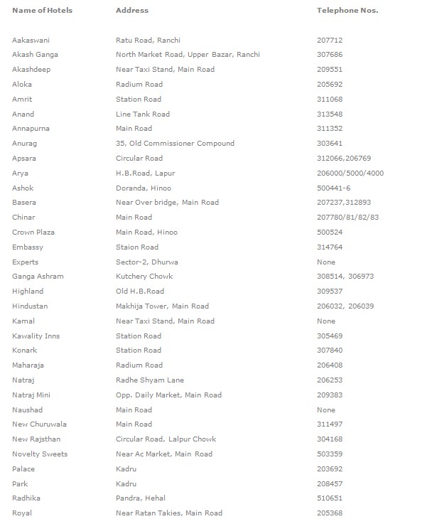
Accommodation
Places to visit
ANGRABADI - Angrabadi is actually, a temple complex,
which accommodates the temples of Lords Ganpati, Ram-Sita
and Hanuman and Shiva. The Shankracharya- Swami Swarupanand
Saraswati, having been captivated by serene, placid
and celestial beauty of Angrabadi rechristened it as
Amreshwar Dham.
BIRSA JAIVIK UDYAN : is situated at a distance of 16
km from Ranchi in Ranchi Ramgarh Road near Ormanjhi.
Many species of animals, trees and plants can be seen
here.
DASSAM FALLS - About 40 km. away from Ranchi on Tata
Road falls a village named Taimara near which flows
the Kanchi river, Falling from a height of about 144
feet Kanchi river makes a pretty fall called Dassam
falls known as Dassam Ghagh also encircled with charming
scences. The tourists are warned not to take bath in
the falls or at least be careful while bathing in the
stream.
GONDA HILL & ROCK GARDEN - About 4 km. from G.P.O.,
Ranchi on Kanke Road, just in fornt of the CMPDIL Hq.
Is situated the Gonda Hill with a water reservoir at
its top. At the foot of the hill is a big lake known
as Kanke Dam and a lucrative place for tourists.
HIRNI FALLS - About 70 km from Ranchi on way to Chakradharpur
is located Hirni Falls. Being situated amidst dense
forest Hirni has been favored by nature for scenic beauties.
The tourists are carried away by emotions and flight
of imagination while observing Hirni.
HUNDRU FALLS - Ranchi is nature's bounty to mother India,
which has specially been adorned with falls and streams.
Hundru falls is about 28 km. away from Ranchi town.
The Swarnarekha River falls from a height of 320 feet
making a wonderful scene known as Hundru falls. During
rainy season it takes a formidable form but in summer
it turns into an exciting picnic spot
JONHA FALLS - Jonha is about 40 km. away from Ranchi.
The road leading to Jonha is a bit narrow but not so
rough and rugged as well as arduous as that of Hundru.
There is also a Tourists rest house that accommodates
Lord Gautam Buddha's temple. This falls is named after
Gautam as Gautamdhara as well. It is approachable by
road. The tourists can go up to Gautamdhara station
by train also.
JAGANNATHPUR TEMPLE & HILL - About 10 km. From Ranchi
G.P.O. is another sight seeing place where the tourists
can rejoice and worship. The old temple of lord Jagannath,
built in 1691 in the architectural style of Puri Temple
stands like a fort on the top of the in the hill. Its
car/chariot festival held light part on Ashadhmas draws
a big crowd comprising of tribal and non-tribal. HEC
township nearby is an added attraction.
MUTA CROCODILE BREEDING CENTRE: is situated at a distance
of 23 km from Ranchi on Ranchi Ramgarh Road near Ormanjhi.
There are around 50 crocodiles.
PANCH GAGH FALLS: is on Ranchi- Chakradharpur Road about
6 kms from Khunti. This fall consists of five streams
which falls from a good height.
RANCHI HILL - Ranchi, being situated at an altitude
of 21,40 feet from sea level, is a popular health and
holiday resort and a place of sacred pilgrimage. Some
comely sights in the town include Ranchi Hill, Tagore
Hill, and Ranchi Lake etc. A panoramic view of the town
can be beyond from the hilltop. The Shiva Temple situated
on the top of the hill, is an added attraction for the
devotees for whom it assumes the places of reverence
during Shravanmas same as that of Baijnath Dham (Deoghar).
SUN TEMPLE - About 39 km. From Ranchi on Tata Road near
Bundu stands on the desolate bush green the elegant
Sun temple fashioned in the form of huge chariot with
richly decorated 18 wheels and seven life like horses
ready to take of. Built by Sanskrit Vihar headed by
Shri Ram Maroo, the managing director of Ranchi Express,
the sun temple deserves the title "a poem in stone".
The surroundings of the temple, studded with a pond
serving as a sacred place for Chhathavratis are actually
a nature's bounty to the people of Chotanagpur. A beautiful
dharmashala, meant for the pilgrims. The all weather
motor able road up to the temple premises is likely
to attract tourists who will be captivated to behold
the newly built sun temple in the placid and serene
surrounding leading to its celestial beauties.
TAGORE HILL - About 3 km. from the Ranchi G.P.O. the
Tagore Hill is about 300 ft. high. As the hill is associated
with a history pertaining to Tagore family, it is known
as Tagore Hill. A number of books are supposed to have
been written by Rabindra Nath Tagore on the top of the
hill. At the foot of the hill are situated the Ramakrishna
Mission Ashram and its office and center of Divyayan
and agrarian vocational institute.
|