|
Nagaland
Nagaland is bound by Arunachal Pradesh and parts of
Assam in the North; Manipur in the South; Myanmar (Burma)
on the East and Assam in the West. 16 major tribes along
with other sub-tribes inhabit the State. Each of the
sixteen odd tribes and sub-tribes have their own languages,
customs and traditions and they can easily be distinguished
by their colourful dresses, ornaments and beads that
they wear. The traditional ceremonial attire of each
tribe is very colourful and attractive.
Nagaland is blessed with a salubrious climate throughout
the year. The temperature from June to September is
between 16 to 31 deg Celsius and from October to February
it is between 4 & 24 degree Celsius.
The main rivers of the state are the Dhansiri, Doyang,
Dikhu, Milak, Zungki and Tizu and the highest peak is
Saramati, which are approximately 3841 metres above
sea level. The land, flora, fauna, the people and their
warm hospitality all combine to make Nagaland and ideal
destinations for the tourists.
Location : Between 25 degree 6' and 27 degree 4' latitude,
North of Equator and between the Longitudinal lines
93 degrees 20'E and 95 degree 15' E.
GENERAL INFORMATION :
Area : 16,527 Sq. km
Population : 19,88,636(Provisional 2001 census).
Capital : Kohima
Districts : Kohima, Mokokchung, Mon, Phek, Tuensang,
Wokha, Zunheboto and Dimapur.
Tribes : Angami, Ao, Chakhesang, Chang, Lotha, Konyak,
Kuki Khiamniungan, Phom, Pochury, Rengma, Sema, Sangtam,
Yimchunger, Zeliang
Temperature : Summer : 16 degree C to 31degree C (June-Sept)
Winter : 4 degree C to 24 degree C (Oct - Feb)
Clothing: Summer : Cotton tropical
Winter : Heavy woolen
Average rainfall : 2000 mm to 2500 mm
Languages spoken : English, Hindi, Nagamese and local
dialects.
Religion : Christianity, Hinduism, Islam, Tribal Religions.
ENTRY FORMALITIES :
FOREIGN TOURISTS : Foreign Tourist are allowed to visit
the eight district headquarters and specified places
for a period of ten days which is extendable for another
ten days provided they are in a group of four or more
or married couples. Permits to visit these places are
issued by Ministry of Home affairs, Government of India,
New Delhi, Indian Missions abroad, Foreigners Regional
Registration office (FRRO), Delhi, Calcutta and Mumbai,
the Chief Immigration Officer, Chennai and the Commissioner
(Home) Government of Nagaland, Kohima.
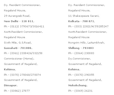
DOMESTIC TOURISTS : Indian tourists require
an Inner Line permit to visit Nagaland. The Permit can
be obtained from the following offices on payment of
a permit fee of Rs.5.00.
FESTIVALS OF NAGALAND :
The Hornbill Festival : Every year, the Department of
Tourism, Government of Nagaland organizes The Hornbill
Festival of Nagaland in Kohima during first week of
December. Almost all tribes of Nagaland dressed in their
traditional and colourful attire including spears and
daos etc. participate in this festival. On sale at the
festival ground are handloom and handicrafts items,
flowers and plants, ornaments, beads, jewellery etc.
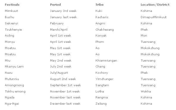
TRIBAL FESTIVALS : Each tribe in the state have their
own festivals, which are celebrated with great enthusiasm.
Some of the important festivals are given below:
Nagaland Dimapur
Dimapur, 74 km away from Kohima is the
commercial town of Nagaland. The town is connected by
air, rail and the National Highway No. 39 passes through
the heart of the town. Nagaland State Transport, private
buses and taxis connect Dimapur with the state capital
and other districts and towns in Northeastern region.
Some of the road distances to important places are given
below:
Amguri-178 Guwahati-292 Imphal-216 Kohima-74 Mariani-Mokokchung-208
Meluri-170 Mon via Jorhat Namtola-208 Wokha via Kohima-154
Peren-84 Zunheboto via Chazouba-224
GENERAL INFORMATION :
Area : 1813 sq km
Altitude : 145 m above sea level
Temperature : Summer: Max-36.4 degrees C Min 14.9 degrees
C
Winter : Min-22.7 degrees C Min 6.3 degrees C
Clothing : Summer : Cotton
Winter: Woollen
Religion : Christianity, Hinduism and Islam
STD/AREA CODE : 03862
WHAT TO SEE-In and around Dimapur
The Ruins of Medieval Kachari Kingdom : A few kilometre
away from the Tourist Lodge and very near the Dimapur
market lies the ruins of the medieval Kachari kingdom.
Remains of the broken pieces of stone pillars and other
stone carvings are to be seen in this place. The site
is now under the administrative control of the Archaeological
survey of India and efforts are on to preserve this
important site.
North East Zone Cultural Centre Museum : A few km away
from the Railway station and half a kilometre from the
Airport, the North East Zone Cultural Centre Museum
is an interesting place for tourists desiring to know
the various cultural heritages of the North eastern
people.
Chumukedima : About 14 km from Dimapur, Chumukedima
was the first headquarters of the then Naga Hills district
of Assam during the British rule. A tourist village
of the Department of Tourism, Government of Nagaland
is located nearby.
Intangki Wildlife Sanctuary : At a distance of around
37 km from Dimapur, this sanctuary is the habitat of
some of the endangered species of birds and animals.
ACCOMODATION :
Tourist Lodge, Govt. of Nagaland, Ph. 226355
Supplementary ACCOMMODATION :
Hotel Tragopan, Golaghat Road, Ph.230351
Hotel Saramati, Super Market, Naga Shopping Arcade,
Ph. 234761
Dimapur Youth Hostel, Opp Railway Station, Ph.26733
Restaurants :
Plaza Restaurant, Church Road, Ph.232389
Breeze Restaurant, Chrch Road, Ph.233030
Beijing Restaurant, Church Road, Ph.235264
Handicrafts : Nagaland Handloom and Handicrafts,
Supermarket
Cultural Troupe/Clubs :
Zivva Voluntary Organisation, Chakasang Zuva Cultural
Club. Contact: V. Phesao, Exhibition Officer, NEZCC,
Ph - 29075
Travel Agencies :
Doyang Travel, SA-43, Super Market, Ph. 29909, 28769;
e-mail Ovung@Yahoo.com
Skyline Travel Agency, Burma Camp, Ph. 222368
Universal Travel & Tours, Naga Shopping Arcade,
Ph.25810
Civil Hospital : Ph - 32224
Police Station : Ph - 27607/32181
Nagaland State Transport (N.S.T) : Ph - 27579
Railway Enquiry : Ph -131
Airlines Enquiry : Ph - 29366
BANKS :
State Bank of India, Ph. 5012/32874
Vijaya Bank, Ph. 32197
Bank of Baroda, Ph. 32761/26138
Allahabad Bank, Ph. 26597
Federal Bank, Ph. 7515/25725
Punjab& Sind Bank, Ph.20935
Indian Bank, Ph.232299
United Bank, Ph.230604
Essential Travellers Info
IN AND AROUND KOHIMA :
ACCOMMODATION :
Tourist Lodge, Govt. of Nagaland, Ph. 222214
PRIVATE HOTELS :
Hotel Pine, Phoolbari, Ph - 222234
Hotel Japfu, P.R.Hill, Ph - 222722
Hotel Evergreen, NST, Ph - 221170
Hotel Capital, Near NST. Complex, Ph - 224365
Hotel Sharon, New Market, Ph - 222731
Hotel Travel Lodge, Near M.L.A Hostel, Ph - 222740
SUPPLEMENTARY ACCOMMODATION :
V.I.P Guest House, Govt. of Nagaland, Reservation:
Deputy Secretary (Home) Ph.222299
M.L.A. Hostel, Govt. of Nagaland Reservation: Secretary,
Nagaland Legislative Assembly, Ph. 222651
Local Transport : Taxis are available for travelling
to various destinations in and around the town. It is
advisable to negotiate rates before hiring.
CULTURAL TROUPE/SOCIETIES :
Sangtam Women Society, C/o Mrs Mapula Regional Employment
Officer, Ph - 222642/242567
Egumbe, C/o President Barruliu NAWA, Zeling; Ph. 223390/222980(R)
Rengma Cultural Society, C/o Kehayi Rengma, President,
Ph. 221503
TRAVEL AGENCIES :
Tour and Travel Agency, Near IOC, Ph. 222022
Nagaland Holidays, Near TCP Gate, Ph. 223356
Naga World Net, D Block, Ph. 222216
Orchid Travels, NST Complex, Ph. 222077
Peak Travels, P.R. Hills, Ph. 221633
TRANSPORT OPERATORS :
Blue Hills Travels, Near IOC, Ph. 221145
Manipur Golden Travels, Near IOC, Ph. 222595
Network Travels, Near IOC, Ph.241077
BANKS :
State Bank of India, Ph. 222666
United Bank of India, Ph. 222453
Bank of Baroda, Ph.222543/221461
Vijay Bank, Ph.222489
United Commercial Bank, Ph. 222681
NAGALAND STATE TRANSPORT STATION, Ph. 221404
POLICE STATION : Ph.222173, Control Room, Ph. 222958
HOSPITAL - Ph. 222916/222155
POST OFFICE : Ph. 222604
INFORMATION OFFICES :
INDIA TOURISM, GUWAHATI, Government of India, Regional
Office, (North East), G.L. Publication Complex, G.S
Road, Ulubari, Guwahati-781 007(Assam), Ph (0361) 2456158,
Fax: 2547407, Website: www.incredibleindia.org E-mail:
indtour@asm.nic.in
INDIA TOURISM, IMPHAL, Government of India, Old Lambulane,
Jail Road, Imphal-795001, Telefax - (0385) 2221131,
Website: www.incredibleindia.org
DIRECTOR OF TOURISM , Government of Nagaland, Kohima-797001
Ph (0370) 243124/222214
Nagaland Kohima
 The
state capital is 74 km from Dimapur, the commercial
town of the State and 142 km from Imphal, the capital
of Manipur. It is located on National Highway No.39
at an altitude of about 1444.12 metres. Kohima is a
beautiful town known to the world for halting the Japanese
forces during the Second World War. In the middle of
the town lies The War Cemetery with beautiful epitaphs
engraved on each graves of officers and men who laid
down their lives in the battle of Kohima. The
state capital is 74 km from Dimapur, the commercial
town of the State and 142 km from Imphal, the capital
of Manipur. It is located on National Highway No.39
at an altitude of about 1444.12 metres. Kohima is a
beautiful town known to the world for halting the Japanese
forces during the Second World War. In the middle of
the town lies The War Cemetery with beautiful epitaphs
engraved on each graves of officers and men who laid
down their lives in the battle of Kohima.
GENERAL INFORMATION :
Area : 4041 sq. km
Altitude : 1,444.12 metres
Population : 78584(Provisional 2001 Census)
Temperature : Summer Max: 25 deg. C Winter 4 deg. C
Rainfall : 1650 mm
Clothing : Cottons in summer and woollens during winter.
Language : English, Nagamese, Hindi
STD /AREA CODE: 0370
ACCESS AND COMMUNICATION :
Air : The nearest airport for Kohima is at Dimapur,
74 km away. Dimapur is connected by air with Kolkata
and the rest of the country. It takes approximately
two hours by car from Dimapur to Kohima.
Rail : Kohima is connected with the rest of the country
through Dimapur. The Dimapur Railway station is just
a five minutes walk from the Nagaland State Transport
station and the Tourist Lodge of the State Tourism Department.
Road : Kohima is connected by a network of roads with
all important cities and towns in the neighbouring states
and major cities in the country. Some of the road distances
to important places in km are as follows:
KOHIMA TO : Agartala-931 Darjeeling-941 Delhi-2514
Dimapur-74 Gangtok-978 Guwahati-364 Imphal-142 Itanagar-534
Kolkata-1536 Kaziranga-204 Mokokchung-162 Mumbai-3458
Shillong-427 Phek-145 Silchar-732 Tuensang-via-Wokha-Mokokchung-269
Zunheboto-150
Local Transport : Taxis are available for travelling
to various destinations in and around the town. It is
advisable to negotiate rates before hiring.
WHAT TO SEE- In and around Kohima
War Cemetery : Located in the centre of the town,
the Kohima War cemetery serene and beautiful is dedicated
to the memory of those officers and men who made supreme
sacrifices in the battle of Kohima where the Allied
forces halted the advance of the Japanese forces in
April 1944. Two tall crosses stand at the lowest and
highest points of the cemetery and in one of the crosses
the following words are written:
WHEN YOU GO HOME
TELL THEM OF US AND SAY
FOR YOUR TOMORROW
WE GAVE OUR TODAY
Museum : Situated in the heart of the town, the State
Museum has a rare collection of artefacts of the different
tribes of the state.
Sales Emporium : Lying in the centre of the town, the
Government Sales Emporium has a good collection of various
types of Naga shawls, and other handicraft items.
Cathedral : It is the largest Cathedral in the whole
of Northeastern region and an important landmark of
Kohima.
Kohima village : For a tourist in search of local colour,
the Kohima village is a good place to start. The place
has a number of traditional wooden gates and wooden
carvings shaped like horns atop some houses.
EXCURSIONS :
Khonoma : 20 km west of Kohima, Khonoma village is
known for the valor, courage and the fighting ability
of its people in the past. To day, the village boasts
of its terracing cultivation on the hill slopes and
for the conservation of rare species of plants and animals
including Blyths, Tragopan an endangered species of
the state.
Southern Angami Villages : Lying near the National
Highway, and on the way to Dzukou valley and the Japfu
peak, some southern Angami villages such as Jakhama,
Kigwema, Viswema, Phesama still retains the ancient
customs and traditions.
Japfu Peak : About 15 km south of Kohima, Japfu peak
that is around 3048 meters above sea level, is the second
highest peak in Nagaland. The peak boasts of having
the tallest rhododendron measuring over 130 ft. in height
and the girth at the base of around 11 ft. The tree
is featured in the Guinness Book of World Records.
Dzukou Valley : Lying behind the Japfu ranges and 30
km away from Kohima, this Valley is situated at an altitude
of around 2438 metres. Rhododendrons and a number of
wild flowers, herbs and plants adorn the valley during
the monsoon.
Dzulekie : 40 km west of Kohima, Dzulekie at 2133 metres
is an ideal place for a quiet holiday. A rare variety
of rainbow trout can be seen in the Dzulakie stream.
ACCOMMODATION :
Tourist Rest House
Reservation : The Director of Tourism, Government of
Nagaland, Kohima, Ph - 222214
Poilwa : A Zeliang tribe village where one can see
the remnants of the traditional culture of Morung or
the boys' dormitory. It is about 52 km from Kohima.
In between Poilwa and Benreu villages one can also see
a number of stone erections, which were put up to, honour
the dead and other important occasions.
Tuophema Village : On the way to Wohkha and about 41
km from Kohima, this village is known for the Tourist
Village that has been developed and maintained by the
village community. Sekrenyi, the festival of purification
of the Angami tribe is celebrated every year in this
place with effect from 25 to 27 of February.
Tseminyu : 55 km from Kohima, Tseminyu is home of the
Rengma tribes. This place is known for Ngada, the popular
festival of the Rengmas, which is held regularly in
the month of November.
Nagaland Mokokchung
A district headquarters, Mokokchung is 162 km from
Kohima via Wokha, 70 km from Zunheboto, 115 km from
Tuensang, 102 km from Amguri (Assam) and 103 km from
Mariani in Assam, Mokokchung is home of the Ao tribes.
The main festivals of the Aos are Moatsu and Tsungrem
Mong celebrated during the first week of May and August
respectively.
GENERAL INFORMATION :
Altitude : 1325.08m
Area : 1615 sq. km
Population : 1,58,324
Temperature : Summer : 29 deg. C Max.
Winter: 15 deg. C Min
STD/AREA CODE: 0369
ACCOMODATION :
Government Circuit House, Ph 226261
WHAT TO SEE - in and around Mokokchung
Longkhum : At an altitude of 1846 metres, Longkhum is
believed to be the temporary resting place of the spirit
of the dead before their final journey. The village
is also known for it exquisite handicraft and handloom
items.
Ungma : Located in the heart of Mokokchung, Ungma is
regarded as one of the biggest villages in Nagaland.
According to legends, the early Ao tribes who came from
Chungliyimti first settled in this village.
Langpangkong Cave : The cave where the Ahom king is
believed to have taken shelter when he fled from Sibsagar(Assam),
due to differences in the royal family.
Molung : The first village where the American Baptist
was established in 1876. The Mission building, which
is still in good shape and the Leechi tree supposedly
planted by Dr. E.W. Clark, adorns the compound of the
Mission.
Chuchuyimlang : A place where Moatsu, an important
festival of the Ao community is celebrated in a traditional
way. The festival is celebrated regularly with effect
from the first to the third of May every year.
Peren : at a distance of about 84 km from Dimapur,
the Zeliang and Kuki tribes inhabit Peren. The Zeliangrong
area is famous for Rani Gaidiliu's caves and sites where
she took shelter during her resistance against the British.
Nagaland Mon
Home of the Konyak tribe of Nagaland, Mon is 357 km
from Kohima via Dimapur and 280 km from Dimapur, 275
km from Kohima via Mokokchung, Tamlu and Wakching. Konyaks
are known for their skilled craftsmanship especially
in woodcarvings, making of daos, guns, gunpowder, headbrushes,
headgears, necklaces etc. The most colourful festival
of the Konyaks is the Aoling festival celebrated in
the first week of April.
GENERAL INFORMATION :
Altitude : 897.64m
Area : 1786 Sq. km
Population : 1,47,699
STD/AREA CODE : 03869
ACCOMMODATION :
Government Circuit House, Ph. 221246
WHAT TO SEE - In and around Mon
Shangnyu Village : In this village ruled by Angh (hereditary
chief) there is a wonderful wooden monument is believed
to have been constructed by heavenly angels. The monument
measuring 8ft in height and 12 ft in breadth consists
carvings of human beings and other creatures. There
are also other memorial stones in front of the Angh's
palace.
Longwa Village : Lying close to the international border,
this village is of special interest to all of us. It
is the biggest of all the villages in the district and
it is ruled by the Angh (heriditary chief) whose house
is partly in the Indian side of the border and the other
half on the Myanmarese (Burma) side of the border and
his jurisdiction extends up to Myanmar and Arunachal
Pradesh.
Chui Village : 8 km from Mon on the Tuensang-Mon route,
the village still retains its own traditions and culture.
Inhabitants of this village are very good craftsmen
especially in gun and gunpowder making including bamboo
and woodworks.
Veda peak : About 70 km from Mon on the east, the peak
offers and excellent view of the river Brahmaputra and
the Chindwin river of Myanmar (Burma).<BR.
Naganimora : Believed to have been named by an Ahom
king in honour of his Konyak queen, Watlong Konyak who
died at Lakhan. Nagani means Naga queen and mora meaning
death. Hence, the place was named Naganimora where the
Naga queen died. Naganimora is connected by rail from
Simulguri in Assam.
Nagaland Phek
A district headquarters, Phek is 145 km from Kohima.
The Chakhesang and the Pochury tribes of Nagaland inhabit
the district. This area is also the habitat of Blyth's,
Tragopan, a rare pheasant found in Nagaland.
GENERAL INFORMATION :
Altitude : 1524m
Area : 2,026 Sq. m
Population : 1,02,156
STD/AREA CODE NO: 03865
ACCOMODATION : Government Circuit House, Ph 23037, 23035
WHAT TO SEE - In and around Phek
Pfutsero : At an altitude of 2,133.60 metres, Pfutsero
is connected with Kohima by a 70 km border road. Nagaland
state transport buses ply regularly on this road. It
is the coldest and highest town in the state and it
is known for its green vegetables, such as cabbages,
spring onions and garlic. Apples are also grown around
this area.
Khezakenoma Village : Believed to be the ancestral
place for many southern Naga tribes, this village can
be reached from Tadubi in Manipur or from Pfutsero.
Shilloi Lake : Lying on the slopes of Indo-Myanmar,
this lake, which looked like a footprint, is also called
Lacham. It is about 300 km from Kohima and it is accessible
only by jeeps, bus or trucks via Meluri. The lake covers
an area of 0.25 to 0.30 sq. km and the local fish known
as Lata is found in abundance.
Nagaland Tuensang
Distict headquarters, Tuensang is about 269 km from
Kohima via Wohkha and Mokokchung and 235 km via Zunheboto.
Six different tribes of the state namely the Changs,
Yimchungers, Khiamniungans, Sangtams, Phoms and Semas,
inhabit the district. Having inhabited by different
tribes, the district is rich in cultural heritage and
their traditional dresses are very colourful.
GENERAL INFORMATION :
Altitude : 1371.60m
Area : 4228 Sq. km
Population : 2,32,906
STD/AREA CODE NO: 03861
ACCOMMODATION : Government Circuit House, Ph.
2045
WHAT TO SEE - In and around Tuensang
Kiphere : Home to the Sangtams,Yimchungers and Semas,
Kiphere is about 254 km from Kohima. Saramati, the highest
peak in Nagaland is situated in this division.
Longtrok : Located at Chungliyimti, 57 km from Tuensang
in Sangtam area, Longtrok means six stones in Ao and
Sangtam.
Nagaland Wokha
A district headquarters, Mokokchung is 162 km from Kohima
via Wokha, 70 km from Zunheboto, 115 km from Tuensang,
102 km from Amguri (Assam) and 103 km from Mariani in
Assam, Mokokchung is home of the Ao tribes. The main
festivals of the Aos are Moatsu and Tsungrem Mong celebrated
during the first week of May and August respectively.
GENERAL INFORMATION :
Altitude : 1313.69 m
Area : 1628.00 Sq. m
Population : 82,612
Temperature : Summer 32 deg. C Max.
Winter 2 deg. C Min
WHAT TO SEE- in and around Wokha
Mount Tiyi : Mount Tiyi is believed by all Nagas that
it is the abode of the departed souls. The peak is a
good place for trekking.
Totsu : About 25 km from Tseminyu via Phiro village
Totsu has an interesting legend where it is believed
that there is a fight between the two different sides
of the hill, one lost the right ear and the other its
head. The place is ideally suited for trekking and rock
climbing.
Liphanyan Governor's Camp : 43 km away from Dimapur,
the camp can be reached from Wokha. It is an ideal place
for river rafting, angling and a good place to view
the river Doyang.
Nagaland Zunheboto
District headquarters, Zunheboto is 150 km from Kohima
via Chazouba and 70 km from Mokokchung. The district
is home to the Sema tribe of Nagaland. The Semas are
a martial tribe and are known for their fighting skills.
Their main festival is Tuluni, which is celebrated during
the second week of July.
ENERAL INFORMATION :
Altitude : 1,874.22 metres
Area : 1255 sq. km
Population : 97,218
Temperature : 22 degrees C Max. 1 degrees C Min
STD/AREA CODE NO : 03867
ACCOMMODATION :
Government Circuit House, Ph. 20325
WHAT TO SEE - In and around Zunheboto
Satoi Range : A natural habitat of the endangered Blyth's
Tragopan, the place is also rich in wild flowers and
plants.
Ghosu Bird Sanctuary : This bird sanctuary is entirely
maintained by the village community with strict anti-poaching
laws. It is a place where migratory birds flock during
the winter and a habitat of more than twenty species
of endangered birds.
|